← Home · Geophysics

MASW / VS30 Shear Wave Velocity Testing in Aylesbury

Together, we solve the challenges of tomorrow.

DETAILS →

A 24-channel seismograph with 4.5 Hz geophones laid out in a linear array along the northern edge of the Aylesbury Vale — that is how we start a typical MASW survey here. The surface waves generated by a sledgehammer source travel through the Gault Clay and Upper Greensand formations that underlie much of the town, dispersing at frequencies that reveal the stiffness profile down to 30 metres. Back in the office the raw records are transformed into a phase velocity–frequency spectrum using the multichannel analysis algorithm, then inverted to produce a 1D Vs profile. For sites near the Bear Brook floodplain we often pair the active survey with passive recordings to reach the full 30 m depth when soft alluvium attenuates the high-frequency signal. The output is a measured Vs30 value that feeds directly into Eurocode 8 site classification — a number that determines the seismic design spectrum for the structure.
Once the dispersion curve is picked and the inversion converges, we cross-check the results against borehole logs from SPT drilling where available, and compare the Vs30 with the NEHRP site classes to ensure the ground model is internally consistent before it reaches the structural engineer.

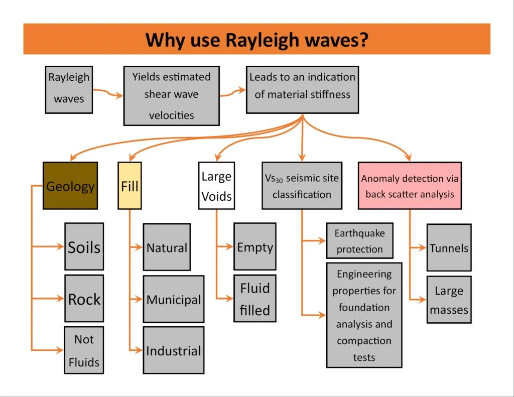
A measured Vs30 of 200 m/s versus an assumed 180 m/s can alter the seismic design spectrum by over 10% — site-specific data pays for itself in foundation optimisation.

Approach and scope

Aylesbury sits at roughly 80 metres above sea level on the Jurassic and Cretaceous strata that dip gently towards the Thames Basin, with a population approaching 85,000 and growing fast under the Aylesbury Vale housing expansion. This growth means new foundation designs must account for the transition zone between the stiff Chalk outcrops on the town's western edge and the softer alluvial deposits along the River Thame corridor. The Vs30 values we measure here typically range from 180 to 220 m/s in the floodplain clays — placing these sites firmly in Class D — rising to 360 m/s and above where the Chalk is shallow, which can shift the classification to Class C. This difference has a direct impact on the base shear calculation in Eurocode 8. For critical infrastructure near Stoke Mandeville we also run the seismic refraction method where a layered P-wave velocity model is needed alongside the Vs profile to characterise rippability and depth to rock head.
MASW / VS30 Shear Wave Velocity Testing in Aylesbury
Technical reference image — Aylesbury

Site-specific factors

Aylesbury's expansion eastwards has pushed development onto the alluvial corridors of the Thame and Bear Brook, where the soft clays and silts extend to depths of 10 to 15 metres before reaching competent strata. The historical pattern of market town growth along the Roman Akeman Street left the floodplain largely undeveloped until the late 20th century — so many of today's building sites lack a legacy of deep geotechnical investigation.
Relying on assumed Vs30 values from regional maps rather than site measurements introduces two risks: overestimating stiffness leads to unconservative seismic designs, while underestimating it forces unnecessary deep foundations or Improvement. In the Aylesbury Vale the natural variability of the Gault Formation means two sites less than 500 metres apart can return Vs30 values differing by 30%. A direct MASW survey eliminates this guesswork and provides defensible numbers for the building control submission under Approved Document A.

Need a geotechnical assessment?

Reply within 24h.

Email: contact@geotechnical-engineering1.com

Technical parameters


ParameterTypical value
Standard referenceBS EN 1998-1:2004 + UK National Annex
Array length46 m to 92 m (24 geophones at 2–4 m spacing)
Source type10 kg sledgehammer on aluminium plate; passive microtremor where required
Depth of investigation30 m (active); up to 50 m with combined passive
Recording instrument24-bit seismograph, 0.5 ms sampling interval
Data processingPhase-shift dispersion imaging, genetic algorithm inversion
Deliverable1D Vs profile, Vs30 value, Site Class per EC8 Table 3.1

Related technical services

01

Standard MASW / Vs30 Survey

A single linear array of 24 geophones with active source, processed to deliver the 1D shear wave velocity profile and the Vs30 value for EC8 site classification. Suitable for residential schemes on plots up to 0.5 ha. Includes the dispersion curve, inversion model, and a signed factual report referencing the borehole or probe data where available.

02

Combined Active–Passive MASW

Adds a passive microtremor array (circular or L-shaped) to extend the depth of investigation to 40–50 m. Recommended for larger commercial projects where the Chalk interface is deeper than 30 m, or where the EC8 site class boundary between C and D must be confirmed with high confidence for the lateral load analysis.

Relevant standards


BS EN 1998-1:2004 (Eurocode 8: Seismic design — General rules), BS 5930:2015 (Code of practice for ground investigations), NEHRP Recommended Seismic Provisions (site classification cross-reference)

Q&A

What does a MASW survey in Aylesbury cost for a typical residential plot?

For a standard active-source MASW survey on a single residential plot in Aylesbury, the cost ranges from £1,440 to £2,510 depending on the array length, access conditions, and whether passive recording is needed to reach the full 30-metre depth. The price includes mobilisation within Buckinghamshire, the raw field data, dispersion processing, inversion modelling, and the signed factual report with the Vs30 value and EC8 site classification.

How long does the fieldwork take and what access do you need?

A standard 24-channel active survey takes around two to three hours on site, assuming a clear linear run of roughly 50 metres for the geophone spread. We need vehicle access for the equipment and permission to use a sledgehammer source — the impact is comparable to a heavy footfall and causes no damage to the ground. If passive recording is added, we leave a seismograph running for 30 to 60 minutes to capture ambient noise, which can be done with minimal personnel on site.

How does the Vs30 value relate to the ground investigation report for building control?

The Vs30 value determines the ground type (A to E) under Eurocode 8 Part 1, Table 3.1, which feeds into the elastic response spectrum used by the structural engineer for seismic design. Under the UK Building Regulations, Approved Document A requires that the ground investigation report includes sufficient data to characterise the site for foundation design — the Vs30 profile satisfies the stiffness component of that characterisation and is cross-referenced with the SPT or CPT data in the ground model.

Can MASW be used on sloping ground or near existing structures?

Yes, with some adjustments. On slopes greater than about 5 degrees we apply a topographic correction during processing and, where possible, align the array along the contour rather than up the slope. Near buildings we reduce the source energy and monitor vibrations to stay well below the BS 7385-2 limits for cosmetic damage. The method has been used successfully on tight brownfield sites in Aylesbury town centre where borehole access was restricted.

Location and service area

We serve projects across Aylesbury and its metropolitan area.

View larger map
ter>